Search
28 Mar 2026
Search
28 Mar 2026
Please allow ads as they help fund our trusted local news content.
Kindly add us to your ad blocker whitelist.
If you want further access to Ireland's best local journalism, consider contributing and/or subscribing to our free daily Newsletter .
Support our mission and join our community now.
To continue reading this article, you can subscribe for as little as €0.50 per week which will also give you access to all of our premium content and archived articles!
Alternatively, you can pay €0.50 per article, capped at €1 per day.
Thank you for supporting Ireland's best local journalism!


The north of Scotland will continue to face harsh weather warnings for snow and ice on Thursday, the Met Office has warned.
Much of the north of Scotland is facing a yellow warning for snow and ice, which has been in force throughout the week, and is due to end at 9pm on Thursday.
It said there would be possible travel delays on roads, delays and cancellations on public transport services, and the risk of injury because of slippery terrain is higher than usual.
Power cuts are also possible and mobile phone signal may be affected.
Rural communities may also be cut off.
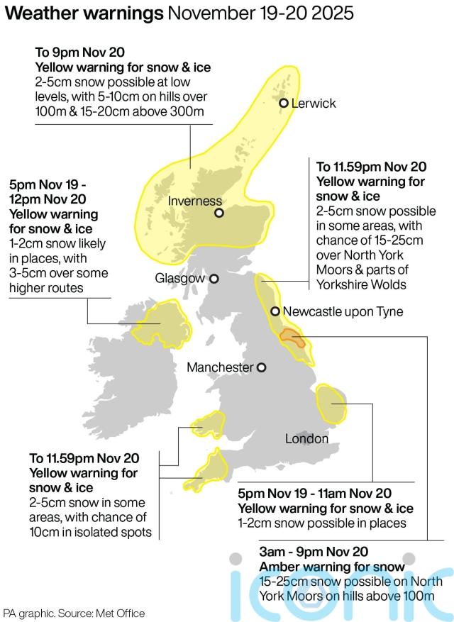
The A90 in Aberdeen was closed in both directions between Cleanhill roundabout and the Stonehaven roundabout on Thursday morning due to snow, with reports of many vehicles stuck.
Police advised motorists to avoid the area.
Many schools in the Highlands and in Aberdeenshire have been forced to shut over the week.
Met Office chief forecaster Neil Armstrong previously said: “Cold Arctic air from the north is firmly in charge of the UK’s weather, bringing the first notable cold snap of this autumn and giving an early taste of winter weather.
“As a result, winter hazards are likely through the next few days, with snow and ice a particular hazard, and the coldest conditions likely on Wednesday and Thursday.
“Wintry showers will affect areas exposed to the brisk northerly wind, in particular Northern Ireland, south-west Wales, south-west England, north-east England and across the northern half of Scotland.
“Whilst not all places will see lying snow, where showers are most frequent accumulations of 2-5cm will be possible.
“On higher ground in Scotland 15-20cm could accumulate and potentially as much as 15-25cm over the North York Moors and Yorkshire Wolds.”

Subscribe or register today to discover more from DonegalLive.ie
Buy the e-paper of the Donegal Democrat, Donegal People's Press, Donegal Post and Inish Times here for instant access to Donegal's premier news titles.
Keep up with the latest news from Donegal with our daily newsletter featuring the most important stories of the day delivered to your inbox every evening at 5pm.
This publication supports the work of the Press Council of Ireland and Office of the Press Ombudsman, and our staff operate within the Code of Practice of the Press Council. You can obtain a copy of the Code, or contact the Council, at www.presscouncil.ie, Lo-call 1800 208 080 or email: info@presscouncil.ie.


