
Rest in Peace Dr Courtney
Search
05 Mar 2026
Please allow ads as they help fund our trusted local news content.
Kindly add us to your ad blocker whitelist.
If you want further access to Ireland's best local journalism, consider contributing and/or subscribing to our free daily Newsletter .
Support our mission and join our community now.
To continue reading this article, you can subscribe for as little as €0.50 per week which will also give you access to all of our premium content and archived articles!
Alternatively, you can pay €0.50 per article, capped at €1 per day.
Thank you for supporting Ireland's best local journalism!


Large parts of England and Wales are expected to be hit with heavy snow this week, brought by the high winds of Storm Goretti, the Met Office has warned.
A yellow weather warning for snow, expected in a large part of England covering Sheffield, Peterborough, Bath and Worcester, and in much of Wales, will be in place from 6pm on Thursday until midday Friday.
The severe wintry weather will be brought by the strong winds over northern France, named Storm Goretti by the country’s forecaster, Meteo France.
The drop in temperatures has triggered cold weather payments for hundreds of thousands of households, designed to help elderly and vulnerable people with heating costs, the Government said.
Eligible households automatically receive £25 when temperatures are recorded or forecast to be zero degrees or below over seven consecutive days.
Payments will support households in 451 postcode areas in England, Wales and Northern Ireland, including Penrith, in Cumbria, the Yorkshire Dales, Norwich, in Norfolk, Milton Keynes, in Buckinghamshire, and Crawley, in West Sussex.
Cold weather payments have been triggered on five separate days, December 30, January 1, January 2, January 3 and January 6, and have been triggered twice for households in parts of Cumbria and Northumberland, which stand to receive a £50 payout.
Snow is likely to develop over higher ground in South Wales late on Thursday, before rain turns to snow more widely across England and Wales overnight, the Met Office said.
Some areas could see 5-10cm of snow settle, while others could see as much as 20cm.
Storm Goretti is also expected to bring disruption in south-west England, with a yellow warning for strong winds in place for Cornwall, Devon and the Isles of Scilly from 3pm on Thursday until just before midnight.
A yellow warning means some disruption is possible, such as travel delays, but many people can continue with their daily routine, according to the Met Office.
An amber warning indicates a higher risk, with severe weather likely to cause travel disruption, power cuts and the potential risk to life and property and people are advised to take precautions.
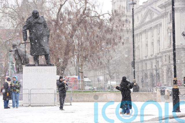
It follows the coldest night of the winter so far, as temperatures plummeted to as low as minus 12.5C in the UK overnight on Monday, following a day of school closures and travel disruption.
The lowest temperature was recorded in Marham, Norfolk, while Santon Downham in Suffolk, and Topcliffe, North Yorkshire, both saw a low of minus 10C, the Met Office said.

In Scotland, the night was coldest in Dalwhinnie and Tulloch Bridge, where temperatures dropped as low as minus 11.2C and minus 10.7C.
An overnight low of minus 9.6C was recorded in Bala, a market town within Snowdonia National Park in North Wales.
Snow continued in parts of the UK overnight on Monday, with as much as 36cm recorded in Loch Glascarnoch.
Hundreds of schools were forced to close across Wales, Scotland and Northern Ireland on Tuesday morning, while National Rail warned of service cancellations and disruption to train services.
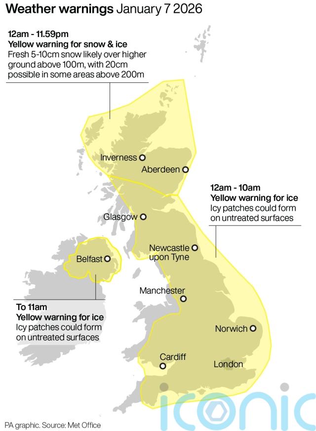
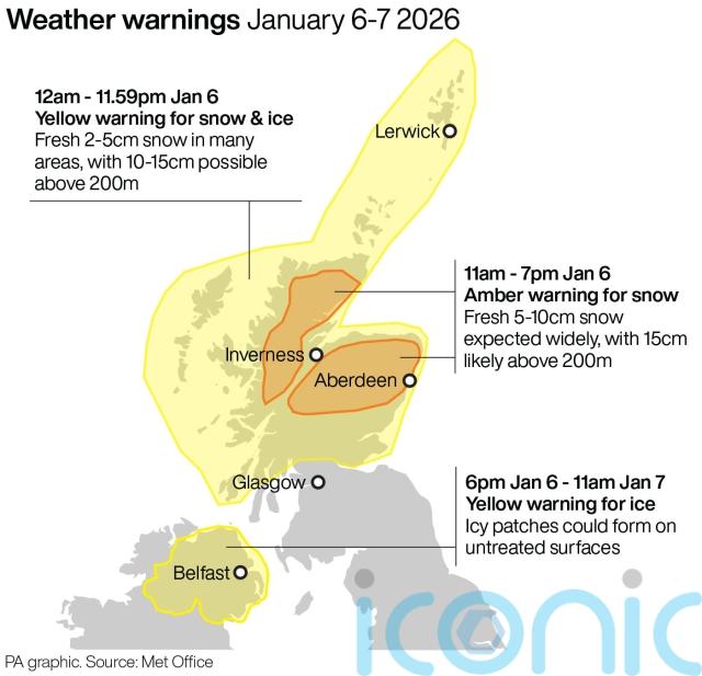
Yellow weather warnings for snow and ice are in place across Wales and north-east and south-west England until 11am, as well as in Scotland and Northern Ireland for much of the day, while an amber warning has been issued for heavy snow across north-east and northern Scotland from 11am until 7pm.
Icy patches are expected into Wednesday, with yellow weather warnings in place until 10am across much of England, Wales, and the south of Scotland, and until 11am in Northern Ireland.
A yellow warning for snow and ice in the north of Scotland will be in place for much of the day on Wednesday.
The UK Health Security Agency (UKHSA) has extended amber cold health alerts for England as an early warning that adverse temperatures are likely to affect health and wellbeing, running until Sunday.
Tuesday morning saw disruption to Wirral and Northern line services, and to trains across Scotland, National Rail said, while breakdown companies including the AA and RAC are experiencing high demand.
The train operator LNER, which runs the east coast mainline, has extended its advice to passengers not to travel between Edinburgh and Aberdeen as they “cannot guarantee” trains will operate until this Friday at the earliest.
A spokeswoman for the AA said its teams had attended almost 13,000 breakdowns by 4pm on Tuesday while the RAC said drivers in the worst-hit areas “need to be considering whether it’s safe to get behind the wheel”.

Subscribe or register today to discover more from DonegalLive.ie
Buy the e-paper of the Donegal Democrat, Donegal People's Press, Donegal Post and Inish Times here for instant access to Donegal's premier news titles.
Keep up with the latest news from Donegal with our daily newsletter featuring the most important stories of the day delivered to your inbox every evening at 5pm.
This publication supports the work of the Press Council of Ireland and Office of the Press Ombudsman, and our staff operate within the Code of Practice of the Press Council. You can obtain a copy of the Code, or contact the Council, at www.presscouncil.ie, Lo-call 1800 208 080 or email: info@presscouncil.ie.


